Hiking in Amorgos — 8 Scenic Trails with Maps & Tips
Hiking in Amorgos spans the island’s backbone and gentle village loops. Below you’ll find distances, times, difficulty, suggested gear, and map/GPX links to plan a safe hike.
Planning more? See Amorgos beaches and traditional villages.
Palia Strata & Central Crossings
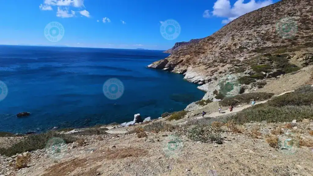
Palia Strata — Chora → Aegiali
Start: Chora (“Kalogerikos” point). Route: Chora → Hozoviotissa Monastery → Kapsala → Asfondylitis → Aegiali.
The island’s longest hike traces its spine with wide sea horizons at ~350–400 m. Ancient paved sections recall the old trade route that once linked Chora with Aegiali.
- Pass Kapsala, the abandoned rural hamlet of Asfondylitis, then Oxo Meria and Ano Potamos.
- Long downhill finish into Aegiali Bay — plan logistics for the return.
- Best in stable weather; avoid strong winds on the ridge.
Itonia — Vroutsi → Katapola
Start: north of Arkesini village. Route: Vroutsi → Katapola.
Links Kato Meria with Katapola following traces of the ancient way between the cities of Minoa and Arkesini. Expect chapels, acropolis remains, the Tower of Agia Triada, Kastrí, and beaches (Ag. Saranta, Finikies) before climbing to the archaeological site of Minoa above Katapola.
- Waymark “3” (white/red) to Vroutsi; sparser beyond toward Katapola.
Chora, Katapola & Sea-View Paths
Fotodotis — Chora → Katapola
Start: “Voreina” (behind Chora). Route: Chora → Milies → Agia Irini → Katapola.
Gentle descent via shady spots, an old dry spring and an oak tree — ending by the small chapel of Agia Irini and the harbour of Katapola.
- Light brush in places; simple waymarks to the bay.
Valsamitis — Katapola → Minoa
Start: Katapola. Route: Katapola → Agios Georgios Valsamitis → Agia Marina → hill of Ancient Minoa.
Short, rewarding walk linking hillside chapels with the panoramic acropolis of Minoa overlooking the harbour.
Aegiali — Peaks, Gorge & Chapels
Melania — Aegiali Bay → Lagkada → Tholaria
Start: Aegiali beach/bay. Route: Bay → Lagkada → Tholaria.
Mountain scenery with valleys, the Araklos gorge, the church of Panagia Epanochoriani and the tiny hamlet of Stroumbos. The air is fragrant with sage and oregano along the way.
- Above Tholaria lie traces of the acropolis of ancient Aegiali (Vigla).
- The village gateway is marked by the church of Agioi Anargyroi.
PAN — Lagkada → Theologos → Stavros → Old Mine
Start: Lagkada, Loza square. Route: Lagkada → Epanachoriani → Agios Ioannis Theologos → Stavros chapel → old bauxite mine.
Ascent toward Mt. Krikellos and the cliffside chapel of Stavros. You pass above the historic bauxite mine (operated until 1943; test drillings 1976–1981). The area is part of the Natura 2000 network.
- Vast views over the southern ridge and the Aegean.
- Take care on the descent from Stavros; avoid strong winds.
- Do not enter abandoned mine galleries.
Lagkada Windmills — Balcony over Aegiali
Start: Lagkada (KTEL bus stop). Route: Steep climb to the ridge above the village to the old windmills.
The last mill worked until 1974. Today the ruins “stand guard” above Aegiali Bay. Expect a rocky, steep track and frequent winds — tread carefully.
Circular & Gentle Routes near Katapola
Evangelistria — Circular from Xylokeratidi
Start: Xylokeratidi (opposite Katapola). Route: Xylokeratidi → Nera → Peristeria → Evangelistria (Byzantine church) → back.
Easy circuit with harbour views. Passes the Katapola cemetery and Vigla to the right before the gentle ascent to the church still used by local herders.